NZ Powelliphanta Snail Habitat Mapping
New Zealand Powelliphanta Snail Habitat Modelling
One of our environmental projects involves habitat modelling for the native Powelliphanta land snails on the West Coast of the South Island. These snails received a large amount of media attention and are considered an endangered species. Our spatial data modelling has identified locations with potential for finding these snails, by analysing sites of ideal habitat conditions in New Zealand.
For this pilot project the entire South Island was modelled using the weights of evidence technique to identify potential habitats for Powelliphanta land snails. This technique allows data to be assessed and weighted according to how well it correlated in relation to the current known locations of Powelliphanta snails.

A number of features important for snail habitat were identified using documentation from the Department Of Conservation (DOC) – “Recovery plans for Powelliphanta land snails” Threatened Species Recovery Plan 49 – K. Walker (2003), and information from the Christchurch based company Sustainability Solutions. Identifying the key elements that make up their habitat was essential before testing began in this project and helped determine which layers to include in the model. The model was run in ESRI ArcGIS using the ArcSDM extension.
The South Island Powelliphanta land snail model was generated with coarse scale data. Data for the model was obtained from Land Environments New Zealand, National Institute of Water and Atmospheric research, Landcare Research, and GNS Science. The data has been managed in a GIS and manipulated using techniques such as grid extrapolation, grid interpolation, theme classification, and neighbourhood statistics.
All themes developed for the model were 200 m by 200 m resolution grids covering the entire South Island. A predictive map produced after completing the model highlighted the areas most favourable as Powelliphanta snail habitats in the South Island. Areas that were identified as being highly suitable correlated well with Sustainability Solutions maps of historical snail locations. These historical snail locations were not known to Kenex during the modelling process and have subsequently verified this model and give us a lot of confidence to continue with our more detailed regional modelling.
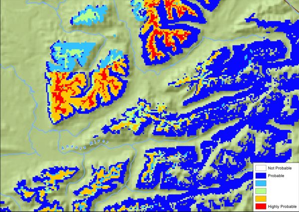
Favourability map of a small region from our South Island model near the Ahaura River on the West Coast. Red and orange areas are the most probable for snail locations.
Plans for the future involve modelling a specific taxon, as six different taxa were used as training data for the initial model; and modelling smaller areas using more detailed data, specifically the Victoria / Brunner ranges and the Mt William ranges.
Learn more about this project
Publications: