NZ Orogenic Gold Potential
Otago, New Zealand
Otago has a rich history of mineral exploration and mining dating back over a century, from the first prospectors who discovered gold and began alluvial operations in the 1800’s through to the Macraes Flat open pit mining in the 1990’s.
The Otago region contains Mesozoic schists, which are well known in New Zealand to host orogenic gold mineralisation. Shear zones in the schists have become structural hosts for gold, which precipitates from fluid produced during metamorphism. Today explorers are using modern geological and geophysical techniques to locate these mineralised shear zones, and Kenex are helping them interpret the wealth of geological data being collected to prioritise their exploration programmes; saving them time, resources, and money. Due to the mineral potential of the region and the wealth of digital geological data available, Kenex have been actively involved in mineral potential mapping studies in the region, and have assisted clients with permit management and follow-up exploration of model targets.
The first GIS-based mineral potential map of the Otago region was undertaken by GNS Science. This team, then led by now Kenex Director Greg Partington, mapped orogenic gold potential throughout the South Island of New Zealand in both the Mesozoic and Palaeozoic schist belts of New Zealand (Partington and Smillie, 2002). Initial mineral potential mapping in 2002 from this study produced large regional targets, as can be seen below in the leftmost image.
In 2004 Kenex undertook a new mineral potential mapping study over the Otago region, using updated geological mapping by GNS Science (QMAP series) and an improved geochemical database to refine the previous results from GNS Science (Partington and Sale, 2004). As shown in the central figure below this updated mineral potential mapping led to a significant size reduction of the prospective area for mineralisation, thus allowing explorers to target areas more precisely for new exploration permits and data collection.
Our most recent phase of mineral potential mapping in Otago was undertaken in 2006 (Hill and Partington, 2007) and used improved geochemical databases and geological interpretations to further refine the prospective areas from the 2004 and 2002 studies.
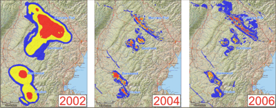
Mineral potential modelling results of eastern Otago from 2002, 2004, and 2006
In 2007 Glass Earth Ltd started an extensive exploration programme over Otago, which began with the collection of regional geophysical data to interpret geology and shear zones under the large areas of fluvial and glacial Tertiary cover units. In subsequent years Glass Earth undertook follow-up geochemical sampling and geological mapping of exploration targets.
Along with Glass Earth, several other exploration companies have collected new geological data throughout Otago. This data, when compiled, will allow new advanced and more detailed studies for orogenic gold and tungsten in Otago to be undertaken.