Guiana Shield Orogenic Gold Potential
Guiana Shield Mineral Potential Mapping and GIS
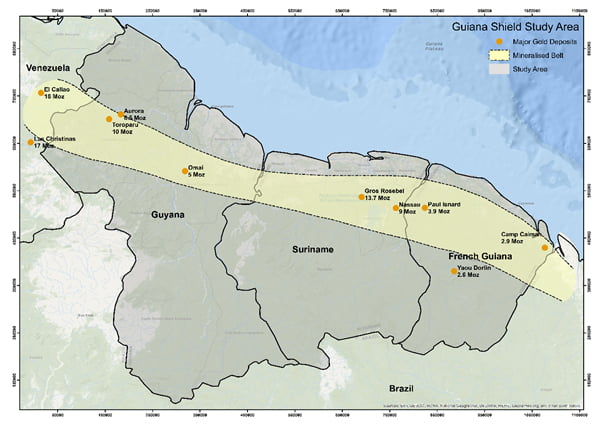
The Guiana Shield is one of four cratons in South America and is located in the northeast of the continent, forming part of the coast. The Guiana Shield underlies Venezuela, Guyana, Suriname, and French Guiana, and is prospective for several types of mineral deposits including orogenic gold and assoicated placer gold deposits, diamonds, and a variety of industrial minerals.
Kenex undertook mineral potential mapping for orogenic gold over the parts of the Guiana Shield that cover Guyana, Suriname and French Guiana using regional scale data. The mineral potential mapping uses the latest GIS tools and technologies and enables effective targeting through the compilation and integration of data in a way that matches the mineralisation model for orogenic gold in the Guiana Shield.
The exploration GIS has been used to:
- Develop a mineral potential map to identify the most prospective area in the Guiana Shield for orogenic gold mineralisation.
- Derive anomalous threshold levels for geological, geochemical, and geophysical data.
- Identify missing data that need to be collected to upgrade the prospectivity of targets.
- QA the database against exploration models being used.
- Review exploration models in relation to current exploration practices.
- Prioritise a list of those geological variables that are the best predictors of mineralisation.
Guiana Shield study area