Cook Islands SBMA
Mineral Potential Modelling and GIS Tenement Platform in the Cook Islands Exclusive Economic Zone
Kenex has been working with the Cook Island Seabed Minerals Authority in order to assess the potential for polymetallic nodule deposits over the Cook Island Economic Exclusive Zone (CIEEZ) and to create an enterprise GIS platform for exploration licence management.
The first part of the project involved collecting and storing in a geodatabase all of the information about nodule abundance and geochemistry from survey cruises. Then a regional mineral potential map for polymetallic nodules was completed in the area of interest, using the compiled nodule information and regional scale data that was available, such as geology, geochemistry, and topographic/bathymetric datasets. The model results were used for prioritizing areas for further research and for implementing tenement planning strategies.
The second part of the project was completed in September 2016 with the development of a complete prospecting and exploration licence GIS management system for the Cook Islands government. Kenex designed and implemented the system, helped with installing the necessary software, and assisted the Seabed Minerals Authority team in training with the new GIS platform.
The mineral potential model
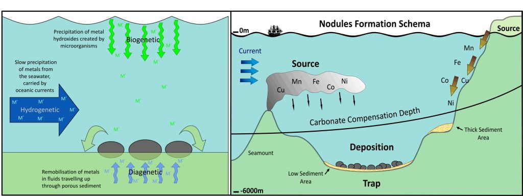
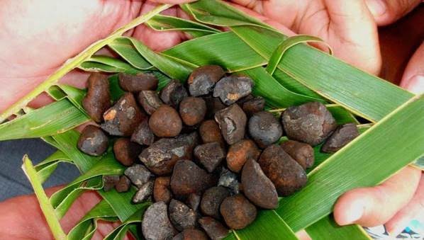
Polymetallic nodules, also known as manganese nodules, have been explored as a possible source for a number of metals including cobalt since the early 1970’s. Recent data on the nodule composition and abundance in the CIEEZ has led to a renewed interest in the potential for manganese nodules in the region. There are a number of factors that affect nodule growth and abundance:
- Manganese nodules form on the deep seafloor as concretions comprising concentric layering of iron and manganese hydroxides around a core.
- They grow at a very slow rate, on the order of millimeters per million years.
- The nodules formed by hydrogenetic processes are most abundant, these are formed by slow precipitation of metals from seawater.
- Nodules are most abundant at depths between 4,000 m and 6,000 m in areas with a low sedimentation rate.
- Hydrogenous nodules generally grow on siliceous and pelagic clay sediment.
To create the manganese nodule mineral potential map, predictive maps were generated using the weights of evidence technique. The data most relevant to manganese nodule formation was used to create predictive maps that best represent the processes in the mineral system model. These predictive maps were combined into a single mineral potential map to show the geological potential of finding polymetallic nodule deposits within the study area. The mineral potential map identified 16 highly prospective and 72 very prospective targets based on their post-probability values. This ranking can be used to prioritise follow-up investigations including assessment of the current target status and collection of additional data.
The Cook Island Seabed Authority can facilitate the use of the model results in several ways. From a planning perspective, these include:
- Structuring any tender process – short, medium, and long term objectives.
- Preparation of acreage for tender.
- Advising on exploration block size for allocation.
- Determining areas to be set aside for economic and/or strategic and/or environmental reasons.
- Identifying appropriate work programme or expenditure requirements from explorers.
- Generating maps to visually aid planning requirements.
- Meaningfully valuing the exploration acreage through the use of probability values to constrain estimations.
Similarly, potential explorers and investors can utilise the model in a number of ways, such as:
- Enabling an estimate to be made of the geological potential of a given location to host polymetallic nodules.
- Allowing for the identification of missing data in areas of lower probability, that if collected could increase the potential of that area for hosting polymetallic nodules.
- Planning and budgeting of exploration programmes.
Learn more about this project
Presentations: