Chatham Rock Phosphate Project
Chatham Rock Phosphate project
Since assisting Chatham Rock Phosphate Limited (CRP) prepare and lodge its initial prospecting licence application in 2007, Kenex has maintained significant involvement in this exciting and unique project.
The Chatham Rise is a large underwater plateau lying east of New Zealand. Extensive phosphate (P2O5) deposits occur along 400 km of the crest of the Chatham Rise at water depths of 400 m or less. The phosphate is formed in nodules which are typically 10-40 mm across but can vary from 1mm to over 150 mm in diameter and are in a sandy layer up to 70 cm thick.
The deposit was formed 7-12 million years ago. It was discovered by New Zealand scientists in 1952 and then subsequently investigated by private companies and government researchers from 1975 to 1981. Extensive sampling and geophysical surveys conducted during this period means the deposit is well defined, with approximately 25 million tonnes of P2O5 identified in the most intensely sampled area, but is likely to be much more in the broader area of interest to CRP.
The project is of one of New Zealand’s most exciting recent resource projects. Studies to date indicate the rock phosphate can be extracted using existing technology for much less than the cost of buying and importing it from Morocco (where most of the phosphate used in New Zealand fertiliser is sourced from). Successful extraction could result in a much reduced carbon footprint from the New Zealand fertiliser industry. The Chatham Rise phosphate also contains lower amounts of toxic impurities. Sourcing this resource locally would significantly reduce New Zealand’s dependency on the political and trade situations of overseas sources. Chatham Rise rock phosphate may also be more environmentally friendly as a fertiliser where it is applied directly to pasture, with previous Government studies indicating less subsequent run-off.
Our key roles for the CRP project and management group has been in the areas of exploration planning and advice, data management and analysis, resource estimation advice, and tenement management. In early 2014 Kenex completed two exciting pieces of work for CRP. These projects – updating the local geology and developing a 3D geological model and mineral potential map – are being used by CRP to aid not only their exploration planning but also their environmental management aspirations. Two 3D geological models were built as part of the efforts to model the geological environments, nodular phosphate distribution, and mineral potential over the central Chatham Rise. The purpose was to confirm and improve upon the existing geological knowledge of the region on both a local scale where the data density is relatively high, and regionally where only seismic data has extensive coverage. The regional model was used to establish parameters to constrain the potential regions of phosphatisation and nodule formation during the Early Paleogene and Neogene periods. The local scale model was built over the mining permit area, to refine structural and geological interpretations. This information was incorporated into the 2D mineral potential mapping.
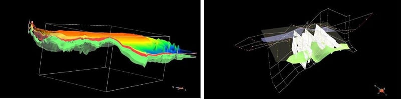
Weights of evidence and fuzzy logic mineral potential models have been implemented, following on from the above discussed 3D geological modelling of the project area. Together, these models are being utilised to facilitate the understanding of the resource distribution and extending key resource variables outside the mining permit, thus helping plan future exploration. The models collectively have also been used by RSC Consulting Ltd to aid in geologically constraining a mineral resource estimate (March 2014) and preparation of JORC compliant technical report.
Learn more about this project
Publications:
- Chatham Rise nodular phosphate – Modelling the prospectivity of a lag deposit (off-shore New Zealand): A critical tool for use in resource development and deep sea mining (purchase only)
- From exploration to extraction: The consequences of resource morphology for mining operation on the Chatham Rise
- Genesis of the Chatham Rise Phosphorite; an interpretation from current literature
Presentations: